 F4LUFTBILDER


Bite between gardens and arable land
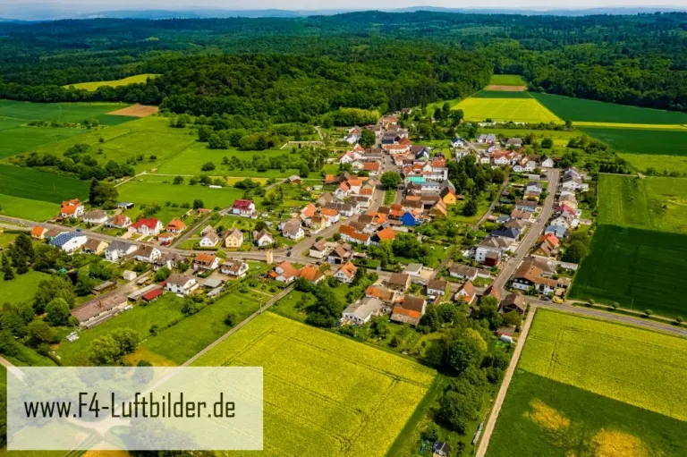
The aerial photos of Bisses show many treetops between the houses. Further out, the small-scale structure changes almost suddenly to the wide fields. Anyone who wants to describe the place will find this change in size a more precise motif than any view of individual roofs.
From the garden to the open hallway
Bisses has a clearly visible outer edge in the aerial view, but inside there are many small green interruptions. This is exactly what distinguishes the view over the village from a pure field panorama. The gardens bring the scale from the large landscaped area back to the individual house.
The center of a town can often be recognized from the air by the intersection of several streets. These lines diverge towards the open landscape, the properties become longer and the distances between the houses become larger. Anyone who chooses an image for a location portrait can pay attention to these transitions. A motif with a piece of the surrounding area tells where the place is. A narrower shot, on the other hand, gives people who live or have lived here more opportunities to find familiar buildings in the picture.
Gardens, paths and open spaces
In gardens, humanly placed forms meet freely growing vegetation. From above, a line of trees can mark a path, even if it is mostly in the shade. When selecting images, the transitions between paved ground, lawn and dense vegetation are interesting. They explain the division of the area. This is particularly helpful when publishing a view of buildings, because the connection between the house, entrance and garden can be seen from the course of the paths.
Field boundaries as a benchmark
On a map, fields become similar areas. In the aerial photo they differ in color, structure and processing direction. A bright dirt path divides two plots, a row of trees interrupts the straight lines. In such places, the size of the open hallway is better understood than by just looking at the horizon. Color changes should initially be left as an observation. Which crop is growing in a field or when it was cultivated can often only be determined from a single photo with additional local knowledge.
Shades of green in the image
If you browse through the 10 aerial photos, you can stay at shot 2 and shot 5 for a comparison. In the first image, green areas make up a smaller part of the section than in the second. It's worth tracking the green areas individually. Only in connection with neighboring forms does it become clear what is in the foreground and what belongs to the more distant surroundings.
For Shot 1 and Shot 6, the same day is noted in the image files, May 23, 2019. The recording times recorded are less than a minute apart. ISO 100 and an exposure time of 1/400 second are recorded for both files.
A moving view is also available. Under Aerial videos you can find the clip “Bisses - The village of Bisses in Hesse from the air”. The linked preview leads to inclusion in the aerial photographer's portfolio on Adobe Stock.
A townscape for chronicle and community
Anyone who wants to show their family their place of origin often first looks for their own house in the aerial photo. When publishing for the community, the task is different. Even a non-local reader should be able to easily follow the path from the core to the landscape. An aerial photographer can start from the same terrain for both purposes and choose the section differently. What counts for the family portrait is the recognizability of a specific property. When it comes to the townscape, however, it is worth adding a little more surrounding area, even if it means that the individual roof appears smaller.
Related motifs in the aerial photo archive
If you are looking for related motifs, you can start with Berstadt. Berstadt stands out in the overview due to its densely built-up core and the longer rows of houses towards the outside. It's worth taking a second look at Beienheim. In the views of Beienheim, the houses form a closed figure between fields of contrasting colors.
Aerial photos of Bisse
Get your offer now!Aerial photos of Bisse in Hesse
The Hessian municipality of Bissen is located in the Hersfeld-Rotenburg district and is part of the East Hesse region. Bissen is a rural town with around 1,600 inhabitants. The municipality consists of the districts of Bissen, Dietzhof, Dorfborn, Eichenrod, Kirchhasel, Lützellinden, Niederlützellinden, Oberlützellinden and Unterlützellinden.
Bissen is a typical Hessian community with lots of greenery and a lot of peace. There are a few small businesses and service providers in the community. The infrastructure is well developed with a primary school, a kindergarten, a bank, a supermarket and several restaurants. There is also a small church in the community.
The area surrounding Bissen is characterized by forests and fields. In the nearby “Rotes Moor” nature reserve, visitors can experience the local flora and fauna up close. The nearby Hersfeld Bad Wildungen also offers many opportunities for leisure activities such as swimming, sauna or hiking.