 F4LUFTBILDER
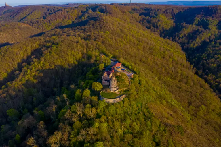


The Bismarck Tower at Rothenburg in Kyffhäuser
The Bismarck Tower near Rothenburg initially appears as just a small accent on the wooded back of the Kyffhäuser. In a closer view, its bright contour and the neighboring structural remains can be seen. The view of the open landscape behind explains the exposed position.
The tower on the forest ridge
At the Bismarck Tower on the Rothenburg, a further look reveals more about the location in Kyffhäuser. In the close view, however, the shape of the building and the transition to the treetops stand out.
Up close, a tower draws the eye upwards. In the aerial photograph this movement is reversed. From the top, the eye follows the sides down to the ground and finds paths, neighboring buildings or vegetation for size comparison. A steep perspective shortens the visible shaft. When viewed from the side, it stands out from its surroundings. When selecting a representative image, it is therefore crucial whether the shape of the tower or its location in the terrain should be shown.
What the treetops reveal
A forest changes the view of every structure and every path that lies on its edge. From one side the treetops cover the lower area, from another a small gap opens. Photos in which the boundary between open space and vegetation can be clearly seen are particularly interesting. They explain which parts of a motif are visible. In a description, it is possible to distinguish precisely between the section depicted and the terrain hidden by the foliage.
The graduation of the mountain ranges
In a mountain landscape the view is divided into the foreground, middle slopes and distant heights. What merges into a closed surface in flat light separates into individual ridges when lit from the side. A gap between two ridges is often enough for the viewer to estimate the depth. For a landscape photograph, this gap is an important part of the subject. If you leave them standing while cropping, the spatial effect is retained even in a smaller image format.
Light and dark areas of the image
For a direct image comparison, use shot 1 and shot 3 from the gallery with 5 aerial photos. In the first photo, light and dark areas are closer together in tonal value. In the second shot the contrast is more pronounced. When switching between photos, it is worth looking from the lightest area to the dark areas. The greater the distance, the more individual contours can stand out, even in a small preview.
According to camera data, Shot 5 and Shot 1 were taken on April 17, 2020. There is a gap of less than a minute between the two images. The exposure time was 1/320 second for the first of the images mentioned and 1/160 second for the second.
Communicate architecture and location together
For a post about a building, two captions can fulfill very different tasks. The first names the system and explains its location, the second leads to a visible component. Historical construction phases or previous uses can hardly be determined from the roof color and current wall edges alone. However, an aerial photographer can show precisely which parts will actually be visible in the later photo. For a guide or local chronicler, this separation makes it easier to work with people who know the local building history.
Related motifs in the aerial photo archive
The article Kyffhäuser Monument offers another perspective. In the aerial view, the Kyffhäuser Monument stands in front of a significantly lower horizon. In the gallery Bismarckturm Bad Kissingen there is a different focus. The bright Bismarck Tower rises above Bad Kissingen from the autumn leaves.
Aerial photos of the Bismarck Tower in Rothenburg
Aerial photography & aerial videos
Your aerial photographer for Rothenburg and the surrounding area
F4 Luftbilder – Your specialist for aerial photography and aerial photography in Rothenburg and the surrounding area. Benefit from our many years of experience and technical equipment and let us convince you of quick implementation and unbureaucratic processing. We look forward to inspiring you with breathtaking aerial photographs and aerial photos in Rothenburg and the surrounding area.
All pictures & videos | 25€Buy now >>>
Aerial photographs & aerial photos of Rothenburg and the surrounding area
Real Estate & Land
Real Estate
We present your property in Rothenburg and the surrounding area perfectly. Discover your property from a completely new perspective and present your property in a modern and contemporary way. Ideal for selling your own house, for real estate agents & architects, as a gift or just for yourself.
Plots
Show your entire property in Rothenburg and the surrounding area with high-resolution aerial photos from above and give potential buyers an overall overview of your property. Ideal for architects, property sellers and real estate agents in Rothenburg and the surrounding area. With aerial photos you also ensure increased visibility in real estate search engines.
 License on Adobe Stock
 Search the Adobe portfolio ↗
Companies & self-employed people
Company
Boost your business in Rothenburg and the surrounding area: Present your company from a completely new perspective. With aerial photos of your company in Rothenburg and the surrounding area you can highlight your product/service. Ideal image material for your company's website and social media channels.
Self-employed people
Present your products/services in Rothenburg and the surrounding area from a bird's eye view. Use impressive aerial photography for your marketing and stand out from the crowd. Feed your local social media channels in Rothenburg and the surrounding area with impressive visual media and win new customers.