 F4LUFTBILDER
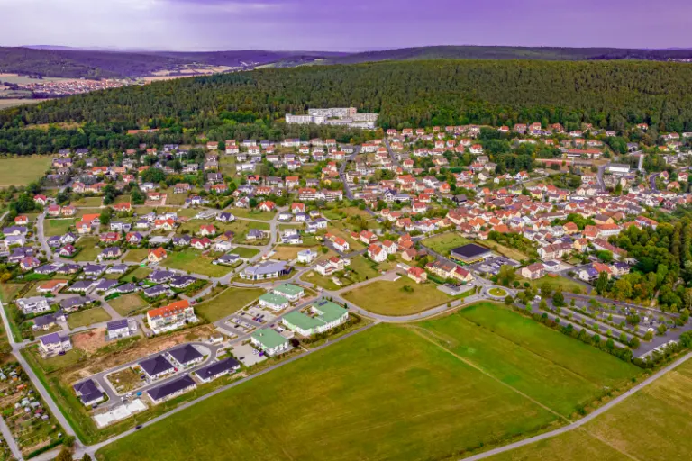


Bad Bocklet on the field corridor
In the aerial photos, Bad Bocklet pushes itself to the edge of open agricultural land. Streets change direction as they follow the terrain. In front of the more distant forest slopes, both the compact settlement center and loosely located groups of houses become visible.
The last gardens before the field
At Bad Bocklet it is informative to look from the outermost house back into the town. The free areas explain the shape of the settlement.
The center of a town can often be recognized from the air by the intersection of several streets. These lines diverge towards the open landscape, the properties become longer and the distances between the houses become larger. Anyone who chooses an image for a location portrait can pay attention to these transitions. A motif with a piece of the surrounding area tells where the place is. A narrower shot, on the other hand, gives people who live or have lived here more opportunities to find familiar buildings in the picture.
What becomes visible on the edge of town
On the edge of town, several scales come together in a small section. On one side there are individual buildings with gardens and driveways. On the other hand, a single open area sometimes takes up as much space as several streets. This change can be shown in the picture over a common edge. A section in which the border between the two areas remains visible even when displayed narrowly is suitable for a website. The motif then retains its local reference even in the mobile view.
Recognize the shape of the valley area
The location in a valley is made clear in the aerial photo by the lateral boundaries. A nearby slope pushes forward in front of a distant one, and the valley floor opens up in between. If the section is too narrow, it can easily give the impression of a flat surface. A shot with a bit of a slope at the edge of the image preserves the context. Orientation is particularly successful when there is also a familiar size comparison, such as a street or a house. The eye can then better assess the depth between the individual landscape levels.
Shades of green in the image
If you browse through the 6 aerial photos, you can stay at shot 2 and shot 5 for a comparison. In the first image, green areas make up a smaller part of the section than in the second. It's worth tracking the green areas individually. Only in connection with neighboring forms does it become clear what is in the foreground and what belongs to the more distant surroundings.
For Shot 1 and Shot 6, the same day is noted in the image files, September 16, 2020. The recording times recorded are about 2 minutes apart. ISO 100 and an exposure time of 1/200 second are recorded for both files.
A townscape for chronicle and community
Anyone who wants to show their family their place of origin often first looks for their own house in the aerial photo. When publishing for the community, the task is different. Even a non-local reader should be able to easily follow the path from the core to the landscape. An aerial photographer can start from the same terrain for both purposes and choose the section differently. What counts for the family portrait is the recognizability of a specific property. When it comes to the townscape, however, it is worth adding a little more surrounding area, even if it means that the individual roof appears smaller.
Related motifs in the aerial photo archive
If you are looking for related motifs, you can start with Burkardroth. The aerial photos show the community of Burkardroth in the Rhön. It's worth taking a second look at Geroda. The development of Geroda stretches between meadows and fields through a shallow valley.