 F4LUFTBILDER
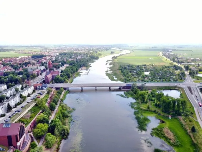


The Marienburg on the Nogat
On the Nogat, Marienburg can be recognized by the extent of its red roofs. The courtyards and building wings stand out clearly from the river surface. From a wider perspective, the castle, the buildings opposite and the bridges can be viewed together.
The castle complex in its river location
At the Marienburg, the Nogat juxtaposes the dense sequence of buildings with an open area. Courtyards and river banks together help to capture the extent of the complex.
When looking at a castle, it is worth looking at the roofs and the spaces between them separately. A large roof wing initially attracts attention. In addition, a courtyard or a narrow passage can show much better how the parts of the system are connected. An oblique aerial photo also gives an idea of their altitude. With a narrower section, a piece of outer wall or slope maintains orientation and allows the building to remain visible in the context of its location.
Follow the watercourse in the picture
A river changes its role with the direction of view. Across the water you can clearly see how close the development is to the bank. A view along the run connects several sections that appear separate from the street. A particularly vivid image is one in which there is a prominent bank in the foreground and a second reference point further back. The eye can then follow the distance between them itself. A picture caption is achieved by indicating which side of the river the main motif is on.
Courtyards and entrances
In a courtyard, the relationships between buildings change. What appears from the outside to be a single long building can actually wrap around several open areas. In a steep aerial view, the passageways, the corners and the orientation of the adjacent roofs become understandable. For a caption, a specific reference to the visible side of the courtyard is often more helpful than a list of all the buildings. This means the viewer can recognize the spatial connection themselves and find it again in other images.
Shades of green in the image
Among the 17 photos in the gallery, shot 7 and shot 11 provide a good starting point for the comparison. In the first image, green areas make up a smaller part of the section than in the second. It's worth tracking the green areas individually. Only in connection with neighboring forms does it become clear what is in the foreground and what belongs to the more distant surroundings.
The camera captured June 16, 2017 for shot 9 and shot 1. The time interval between these two views is approximately 133 minutes. The exposure time for the first of the images mentioned was 14/11015 seconds and for the second 15/5042 seconds.
Communicate architecture and location together
For a post about a building, two captions can fulfill very different tasks. The first names the system and explains its location, the second leads to a visible component. Historical construction phases or previous uses can hardly be determined from the roof color and current wall edges alone. However, an aerial photographer can show precisely which parts will actually be visible in the later photo. For a guide or local chronicler, this separation makes it easier to work with people who know the local building history.
More aerial photos for comparison
Two further articles invite comparison. In the first, Neuhaus am Inn Castle, a different detail is in the foreground. Neuhaus am Inn Castle stands on a narrow area bordered by water. Then you can go to Slovakia – Strecno Castle. Strečno lies on a steep rock above the Waag.
Aerial photos of Marienburg in Poland
Your aerial photographer across Europe
Request a free quote