 F4LUFTBILDER
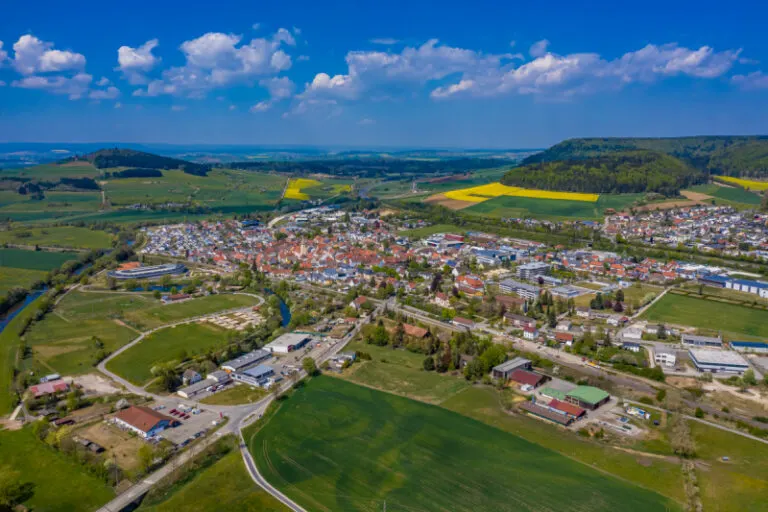


Geisingen in the open Danube valley
In Geisingen, traffic axes, larger commercial areas and the town center are located in an open valley area. The Danube and green bank areas draw softer lines than the streets. A view with both structures makes the different uses around the city easy to understand.
The straight and the curved lines
In Geisingen, traffic routes and fields can be traced into the open valley area. A turnoff to the town explains how the longer lines connect to the local road network.
The location in a valley is made clear in the aerial photo by the lateral boundaries. A nearby slope pushes forward in front of a distant one, and the valley floor opens up in between. If the section is too narrow, it can easily give the impression of a flat surface. A shot with a bit of a slope at the edge of the image preserves the context. Orientation is particularly successful when there is also a familiar size comparison, such as a street or a house. The eye can then better assess the depth between the individual landscape levels.
Follow a line through the area
A traffic route gives direction to an aerial view. From above you can see where the route is, where it adapts to the terrain and where another path crosses it. An easily recognizable crossing is particularly useful for an illustration. It arranges the section in the larger network and brings together different proportions. A second look along the route can then show how the line from the first image continues into the adjacent landscape.
Field boundaries as a benchmark
On a map, fields become similar areas. In the aerial photo they differ in color, structure and processing direction. A bright dirt path divides two plots, a row of trees interrupts the straight lines. In such places, the size of the open hallway is better understood than by just looking at the horizon. Color changes should initially be left as an observation. Which crop is growing in a field or when it was cultivated can often only be determined from a single photo with additional local knowledge.
The distribution of blue tones
To switch between two of the 8 aerial photos, shot 5 and shot 1 can be called up directly in the gallery. In the first excerpt, shades of blue play a smaller role. In the second shot, blue areas take up more space. Blue can extend over a large contiguous area or only appear in individual parts. What also counts for the effect is whether these areas extend to the edge of the picture or surround the main subject.
Shot 8 and Shot 1 are among the views from April 25, 2020. According to the camera's time information, there is about a minute between the two images. ISO 100 and an exposure time of 1/500 second are recorded for both files.
A moving view is also available. The clip “Geisingen from the air” can be found under Aerial Videos. The linked preview leads to inclusion in the aerial photographer's portfolio on Adobe Stock.
Select landforms for a landscape portrait
A single contour line can shape the impression of a landscape and yet reveal little about its extent. For a printed panorama, it is worth looking at the widest view first and then at a section of the same area. In a small format, a foreground with a clear contour can become more important than the most distant peak. If you plan a new view with an aerial photographer, you can make this decision based on the intended page layout and clarify in advance which part of the landscape definitely belongs in the picture.
Related motifs in the aerial photo archive
Two additional views can be used in the archive for comparison. The first can be found under Mühlheim an der Donau. The overview of Mühlheim an der Donau shows a juxtaposition of dense settlement areas and wide meadows in the valley. The second belongs to the article Bad Emstal. The Hessian community of Bad Emstal is seen from above as a series of built-up areas between fields and forest.
Aerial photos of Geisingen
Aerial photography & aerial videos
Your aerial photographer for Geisingen and the surrounding area
F4 Luftbilder - Your specialist for aerial photography and aerial photography in Geisingen and the surrounding area. Benefit from our many years of experience and technical equipment and let us convince you of quick implementation and unbureaucratic processing. We look forward to inspiring you with breathtaking aerial photographs and aerial photos in Geisingen and the surrounding area.
Services
Aerial photos in 4K resolution
Aerial videos in 4K resolution
Individual perspective wishes
Including image editing
All necessary permits and insurance
Free travel to Geisingen and the surrounding area
Your advantages
Direct contact person
No appointment required
Unbureaucratic & short-term processing
Pay conveniently by invoice: bank transfer & Paypal
Delivery of images conveniently via download
Order processing within 10 days
Request a quoteGeisingen from above – breathtaking aerial photos
Geisingen from the air
Geisingen is a municipality in the Breisgau-Hochschwarzwald district in Baden-Württemberg. The city lies at the foot of the Feldberg, the highest mountain in the Black Forest. It also forms the center of the European city of Hochrhein, which also includes the neighboring communities. Geisingen is particularly interesting because of its breathtaking aerial photos. These not only show the impressive landscape around the city, but also the buildings and sights of the city itself in all their splendor - viewed from above, Geisingen looks like a little fairytale land!