 F4LUFTBILDER
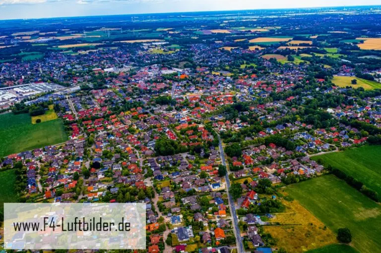


Ganderkesee's town center in the northern German plain
Over Ganderkesee the view extends far beyond the town center. The roofs stand between many trees, and towards the horizon open areas mix with the buildings. The transition where the end of a street is clearly visible is particularly helpful for a view of the town.
A wide view over the town center
Ganderkesee can be easily classified based on the flat horizon. Without large differences in height, streets, rows of trees and the staggering of roofs gain more weight for the townscape.
The gaps between the houses reveal how tightly built the place is. An inner courtyard opens up the roof structure, a treetop covers part of it, and a wide street separates two blocks. Anyone who looks at the photo can follow these gaps and get a clearer picture than if they tried to identify each building individually. A particularly suitable view for a city portrait is one in which the view from a clearly visible roof can move on to the neighboring streets.
What becomes visible on the edge of town
On the edge of town, several scales come together in a small section. On one side there are individual buildings with gardens and driveways. On the other hand, a single open area sometimes takes up as much space as several streets. This change can be shown in the picture over a common edge. A section in which the border between the two areas remains visible even when displayed narrowly is suitable for a website. The motif then retains its local reference even in the mobile view.
The distance in the composition of the image
The position of the horizon determines how much space the landscape receives. If it is high in the image, more details can be seen on the ground. A lower horizon gives greater weight to the sky and weather. Both options can accurately describe a place if the connection to the main motif remains recognizable. When comparing two aerial photos, it is worth taking a look at the foreground. Often it is an inconspicuous piece of land at the bottom edge of the picture that conveys a sense of the vastness.
The distribution of blue tones
For a direct image comparison, use shot 9 and shot 8 from the gallery with 10 aerial photos. In the first excerpt, shades of blue play a smaller role. In the second shot, blue areas take up more space. Blue can extend over a large contiguous area or only appear in individual parts. What also counts for the effect is whether these areas extend to the edge of the picture or surround the main subject.
According to camera data, Shot 10 and Shot 1 were taken on July 20, 2019. There is a gap of around 3 minutes between the two images. The exposure time was 1/200 second for the first of the images mentioned and 1/160 second for the second.
A moving view is also available. The clip “Ganderkesee in Lower Saxony from above” can be found under Aerial videos. The linked preview leads to inclusion in the aerial photographer's portfolio on Adobe Stock.
Prepare a cityscape for readers
A local person will often recognize a street by a single roof. Anyone who sees the city for the first time needs more clues. For a city guide, a short caption can best start at a visible intersection and lead the eye from there to the actual subject. The aerial photographer sees the surroundings outside the section while taking the picture. Readers will later only see the published area. Especially when cropping later, it is worth checking whether the connection described can still be seen in the final image.
Related motifs in the aerial photo archive
The article Vechta offers another perspective. In Vechta, the agricultural area extends right up to the residential areas. In the Fladen gallery there is a different focus. Fladen shows a dense red core in the overview.
Aerial photos of Ganderkesee
Aerial photography & aerial videos
Your aerial photographer for Ganderkesee and the surrounding area
F4 Luftbilder – Your specialist for aerial photographs and aerial photography in Ganderkesee and the surrounding area. Benefit from our many years of experience and technical equipment and let us convince you of quick implementation and unbureaucratic processing. We look forward to inspiring you with breathtaking aerial photographs and aerial photos of Ganderkesee and the surrounding area.
Services
Aerial photos in 4K resolution
Aerial videos in 4K resolution
Individual perspective wishes
Including image editing
All necessary permits and insurance
Free travel to Ganderkesee and the surrounding area
Your advantages
Direct contact person
No appointment required
Unbureaucratic & short-term processing
Pay conveniently by invoice: bank transfer & Paypal
Delivery of images conveniently via download
Order processing within 10 days
Request a quoteSeen from above: The most beautiful aerial photos of Ganderkesee
Ganderkesee from the air
Ganderkesee is a municipality in Germany and impresses with its beautiful aerial views. The landscape is green and idyllic and there are numerous lakes. The people who live here are friendly and helpful. The aerial photos of Ganderkesee are impressive and reveal the beauty of the surrounding area. Viewed from above, Ganderkesee shows a completely different, fascinating side. The aerial photos in this blog article provide a breathtaking insight into the beauty of the region and leave visitors in awe. Viewing Ganderkesee from the air is a real feast for the eyes. The city in the area surrounding Bremen offers everything your heart desires: from the medieval market town to the lively city center with lots of shopping opportunities and restaurants. But Ganderkesee has much more to offer: breathtaking natural landscapes, extensive fields and meadows as well as idyllic forests line the urban area and invite you to take long walks or bike rides. The small villages around Ganderkesee are also worth a visit - especially on sunny days when the colorful houses shine in the sun!
The most beautiful motifs
Ganderkesee is a municipality in the Oldenburg district in Lower Saxony. It belongs to the Weser-Ems region and has around 16,000 inhabitants. The municipal area is 50.6 square kilometers, making it the third largest municipality in the Oldenburg district in terms of area.
Ganderkesee lies on the edge of the Geest northwest of Bremen on federal highway 213 between the Wiehengebirge in the southeast and the Jade Bay in the northwest. How nice it is to see the world from a bird's eye view. The aerial photos of Ganderkesee are really impressive and show once again what a variety of motifs and views there are in our community. Whether idyllic landscapes or impressive buildings – there is a lot to discover from above! When you look at Ganderkesee from above, you immediately notice the many beautiful motifs. The city is surrounded by beautiful countryside and there are many interesting places to discover.
One of the most beautiful motifs is certainly the Great Sea Bush. This lake is the largest inland lake in North Rhine-Westphalia and offers a beautiful backdrop for photos. The many small islands in the lake are also a popular subject for aerial photographs.
Another beautiful motif is the harbor of Ganderkesee. Here you can watch the many boats and ships coming in and out of the harbor. The bridge that connects the harbor with the Meerbusch is also a popular photo opportunity.
The Rehberger Graben nature reserve is also worth a visit. Here you can observe many different species of birds and enjoy the beautiful nature.
Ganderkesee from above – unique perspectives
Due to the many rivers, canals and fields, Ganderkesee is a landscape that is ideal for aerial photography. The different perspectives always give the photos new facets and make them a unique experience. Whether at sunset or in the midday sun - every shot is something special and invites you to dream. You've probably seen many photos of Ganderkesee - but never from a bird's eye view. Because in the aerial photos that I have put together for you here, the village with its extensive fields and meadows, the forest in the hinterland and the small lakes looks like a miniature landscape. The view from the water is particularly attractive: the reflections of the trees and houses in the small ponds form almost surreal patterns. You can't get enough of a view like that, can you? Viewed from above, there is a lot to discover in Ganderkesee. The most beautiful aerial photos of the region offer unique perspectives on the landscape, architecture and people.
The Ganderkesee flight area is known for its breathtaking views. The region offers a variety of interesting locations that are perfect for aerial shots. Whether famous sights like the Teufelsberg or hidden treasures like the idyllic Loccum Monastery - there is a lot to discover from above.
The architecture in Ganderkesee is also unique and offers great motifs for aerial photographs. The magnificent mansions, the old factories and the picturesque half-timbered houses are just some of the highlights that can be viewed from above.
But the most beautiful aerial photos of Ganderkesee are perhaps the ones in which the people can be seen. Whether at a festival, during sports or at a game - the residents of the region show their joy of life and their tradition-conscious nature in their everyday scenes.